Marin Mountains 200K
part of the SFR Adventure Series
UPDATE: in 2025 the San Francisco Randonneurs are running the Marin Mountains 200K on April 26. Register here. The course is substantially different, so we have called it Marin Mountains III.
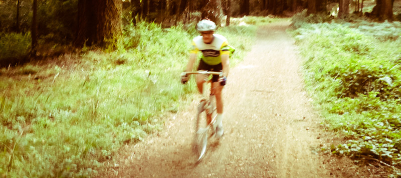
The Old Caz 300K and King Ridge 400K are not so much “mixed-terrain” rides as challenging road rides with a few miles of dirt roads sprinkled in for color. The Marin Mountains 200K, on the other hand, feels more like a mountain bike ride that uses pavement to connect epic stretches of dirt. Most riders will walk once or twice, but the scenery and sense of immersion in nature more than make up for the occasional difficulty.
The distinguishing feature of the Marin Mountains 200K are five long and spectacular unpaved sections.
- From Panoramic Highway to the summit of Mount Tam (mile 14). Five miles of well-graded gravel fire roads through mixed conifer forests. On a clear day, you'll enjoy a commanding perspective on San Francisco Bay. On a foggy day, you'll break through mist into early morning sun and see the fog roll over the Golden Gate like a giant slow-motion wave.
- From Ridgecrest Boulevard to Sky Oaks Road (mile 21). Five miles through mixed forest and mediterranean scrub. Some very steep grades, both uphill and downhill. Mostly gravel and dirt, but also hard-baked clay and challenging rocky sections on aptly-named Rocky Ridge Road. Fine views of San Pablo Bay and the Mount Tam watershed.
- From Bolinas-Fairfax Road to San Geronimo (mile 29). Five and a half very tough miles—the most difficult of this ride. Short but steep climbs on Pine Mountain Fire Road precede a long, precipitous descent on Sylvestris Fire Road. Brief sections of loose softball-size rocks are virtually impassable to road bikes. While many cyclists will walk a couple hundred yards of this segment, most will also enjoy a fantastic feeling of wilderness and expansive vistas of northern Marin.
- Summit of Mount Vision to Limantour Road (mile 82). Only three miles, but that includes rutted single-track and some difficult rocky stretches. Pause at a sharp right turn in the trail to admire exceptional views of Tomales Bay and west Marin.
- Highway 1 to Ridgecrest Boulevard (mile 97). Eleven miles, most of it through wonderful coastal redwoods. One of the prettiest stretches of forest in the Bay Area—a cathedral of big trees. Much of the trail is soft dirt littered with vegetation, and there are only a few short rocky stretches. Two or three short climbs are quite steep: downshift early or you risk walking!
There are also some noteworthy paved climbs, including:
- The Marshall Wall (mile 56). 500 feet vertical in a little over a mile, for an average grade of about 9%—but a quarter of that is flat! The road traverses open grassy terrain with hardly a tree in sight, so the wind can make for hard going.
- Mount Vision (mile 78). An easy climb (1200ft in 4mi) notable for its remoteness and beauty. In half a dozen pre-rides we've only ever seen one car. And on a sunny day the panorama of Point Reyes and Drake's Estero is superlative.
- The “Seven Sisters” on Ridgecrest Boulevard (mile 104). A standard weekend ride for SF roadies, but usually not after a hundred miles and 11,000 feet of climbing. As on Mount Vision, the scenery on a clear day is breathtaking.
Equipment advice
The MM 200K is 23% dirt—roughly one mile of trail for every three miles of pavement. The dirt parts are difficult enough that many riders may opt for a mountain bike, but keep in mind that overly knobby tires or excessive suspension will slow you down on pavement. We suggest a suspension-free bike with a low gear close to 1:1 (for example, 50x34 compact chainrings coupled with an 11-32 mountain cassette) and slick to moderately knobby tires in the range of 32-40mm.
Also, traditional three-bolt road cleats are not a good idea—bring shoes that are comfortable for walking.
Other general advice
- Littering is never cool, but even less so in pristine state parks and county watersheds. Make sure your used energy bar wrappers stay in your jersey pockets. For example, store them in a zip-loc bag weighted with keys or pebbles.
- Do not lock your rear wheel when braking on dirt. It is a stupid move that damages the trail for everyone and gives cyclists a bad name.
- Yield to horses and pedestrians on trails.
- Carry plenty of water and an extra tube and patch kit.
- Bring a camera, and stop long enough to use it.